
miércoles, 23 de mayo de 2012
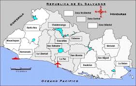
San Miguel is a department of El Salvador. Its provincial capital is San Miguel, a city located 138 km from San Salvador. Bordered on the north by the Republic of Honduras, on the east by the departments of Morazan and La Union, on the west by the departments of Cabañas and Abroad, and the south by the Pacific Ocean. It covers an area of 2077.1 km ² and has a population of over 480,000 inhabitants. The department was declared June 12, 1824.
History
Marked by historic events
The department's history is written with important facts, which show the social and economic development of San Miguel, also known as "Pearl of the Orient". Lenca culture flourished here. When the Spanish arrived in the eastern Uluas encountered the indigenous. On June 12, 1824 San Miguel was appointed as an independent province of the Mayor of San Salvador and was given the name that is known today.
• On May 8, 1530 was founded the city of San Miguel by Don Pedro de Alvarado.
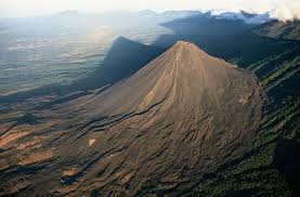
• In 1763, the volcano Chaparrastique made its first eruption.
• On July 15, 1812, the General and Extraordinary Cortes granted to the department head the title of "Very Noble and Loyal City".
• On March 12, 1856 the city was destroyed by fire.
• In 1862, General Gerardo Barrios began construction of the cathedral.
• In 1874 San Miguel became the first telegraph line.
• On September 15, 1892 was introduced electric service.
• On December 31, 1909 the theater opened.

The department's history is written with important facts, which show the social and economic development of San Miguel, also known as "Pearl of the Orient". Lenca culture flourished here. When the Spanish arrived in the eastern Uluas encountered the indigenous. On June 12, 1824 San Miguel was appointed as an independent province of the Mayor of San Salvador and was given the name that is known today.
• On May 8, 1530 was founded the city of San Miguel by Don Pedro de Alvarado.
• In 1763, the volcano Chaparrastique made its first eruption.
• On July 15, 1812, the General and Extraordinary Cortes granted to the department head the title of "Very Noble and Loyal City".
• On March 12, 1856 the city was destroyed by fire.
• In 1862, General Gerardo Barrios began construction of the cathedral.
• In 1874 San Miguel became the first telegraph line.
• On September 15, 1892 was introduced electric service.
• On December 31, 1909 the theater opened.

Carnival of San Miguel
The Carnival of San Miguel is one of the most important popular celebrations of El Salvador, which takes place every November, during the festivities of the city of San Miguel.
Initially the festivities were held every May 8, date of founding of the town. In such celebrations dominated commercial transactions of merchants from various parts of Central America. In 1939 the City Council decided to move the celebration to November 21 in honor of Our Lady of Peace, the patron of the population. During that time local festivals were held in the neighborhoods of the city. As the years passed, casinos in the town dancing festivals were developed, and where income had a small group of people. These locations include the Casino Migueleño. While this was happening, outside of the box, the bulk of the population is content to listen to the music of the bands that gave life to the celebration. Among the most important collections of those years the Orchestra include polio, Paquito Palaviccini1 and Lito Barrientos.
In 1959 the celebrations took a different turn. That year he was appointed as Governor Miguel Felix Charlaix Department, who, noting the isolation of the majority during the celebrations, decided that the orchestra had their presentations on the streets of the city. Two years after its inception, the carnival had an international character with the visit of Guatemalan President Miguel Ydigoras Fuentes and the five Central American beauty queens. Over the years the popularity of carnival spread throughout El Salvador and neighboring countries, to the point of self-proclaimed, in recent times, as the most important holiday of Centroamérica.2 A significant part of the audience is made up of Salvadorans living in abroad, especially in the United States.
"San Miguel Carnival", played by Gil Medina, is a song that has accompanied this festival right from the start. Its creator, Francisco Palaviccini, 4 was composed of Xuc paced, well out of his invention. The most memorable verse shows the indiscriminate invitation to anyone wishing to attend the party:
Historic Landmarks
National Theatre.
 Construction began on January 1, 1903 and was inaugurated on December 31, 1909. Theater offered three sections, each corresponding to different social classes of the time. The boxes the occupied upper class, the window, the middle class, and the gallery was intended for the common people.
In 1914 and 1915 he entered the cinema and for 1927 the exhibition of films have captured the activity of the theater. In 1975, the Ministry of Finance gave the property to the Ministry of Education, which thereafter undertook its restoration, taking into account its historical, architectural and aesthetic cultural development within the Salvadoran
Cathedral . On November 21, 1862 he laid the first stone of what is now the Cathedral of San Miguel. This was an effort by General Gerardo Barrios and she is the patron saint of El Salvador: Our Lady of Peace. The Cathedral is located in the heart of the city, and from any point of it can be observed both pointed and lofty towers of the facade. Many of the materials used in its finish were brought from abroad.
The tiles were imported from Belgium, the bells from Germany, the stained glass depicting biblical figures were made in Mexico, and the altar (of marble), wherein lies the image of Our Lady of Peace, was brought of Italy. In 1913, Pope Pius X raised to the church the title of Diocese and was assigned to the bishop of San Miguel Dueñas the priest Juan Antonio and Argumedo, to care and expedite the construction work and provide the people from San Miguel Cathedral to the religious.
Construction began on January 1, 1903 and was inaugurated on December 31, 1909. Theater offered three sections, each corresponding to different social classes of the time. The boxes the occupied upper class, the window, the middle class, and the gallery was intended for the common people.In 1914 and 1915 he entered the cinema and for 1927 the exhibition of films have captured the activity of the theater. In 1975, the Ministry of Finance gave the property to the Ministry of Education, which thereafter undertook its restoration, taking into account its historical, architectural and aesthetic cultural development within the Salvadoran
Cathedral .
On November 21, 1862 he laid the first stone of what is now the Cathedral of San Miguel. This was an effort by General Gerardo Barrios and she is the patron saint of El Salvador: Our Lady of Peace. The Cathedral is located in the heart of the city, and from any point of it can be observed both pointed and lofty towers of the facade. Many of the materials used in its finish were brought from abroad.The tiles were imported from Belgium, the bells from Germany, the stained glass depicting biblical figures were made in Mexico, and the altar (of marble), wherein lies the image of Our Lady of Peace, was brought of Italy. In 1913, Pope Pius X raised to the church the title of Diocese and was assigned to the bishop of San Miguel Dueñas the priest Juan Antonio and Argumedo, to care and expedite the construction work and provide the people from San Miguel Cathedral to the religious.
Quelepa
 Quelepa or "Jaguars and pumas stone" is considered by archaeologists as the most important ceremonial center in the country's history.
Located five miles north of San Miguel, with an area of six kilometers and an altitude of 230 meters above sea level, was the shelter Quelepa an ancient origin population Lenca. For years the site has been excavated by archaeologists and abroad, as Atilio Pecorine in 1913 and from 1949 to 1959, Willys Andrews, Tulane University, USA, returned to the previous data and found pyramidal platform eight feet mounds 10.
Other discoveries are the "Altar of the Jaguar", which followed the sacrifices Lenca, features performances of heads of snakes and the face of a big cat on display at the National Museum "David J. Guzman. "Also found fossils, pottery, jade, marble, brass, obsidian and others. Other sites of archaeological importance are the village of El Obrajuelo, Moncagua and Uluazapa
Crafts
• San Miguel: candy, flowers, piñatería, nylon cast nets, wooden toys, leather and tin.
• Sesori: florist, baskets, brooms, cigars, iron, tin, pottery.
• New Eden de San Juan: crates and Tbsp nose, adobes.
• San Gerardo: florist, olive tree soap, gourds, pottery, hajalatería.
• San Luis de la Reina: candy, flowers, embroidery, basketry, purería, pottery, tin.
• San Antonio del Mosco: tearoom, basketry, mat weaving and soap Aceituno.
• Carolina: confectionery, hats, baskets, woven mat, yaguales, soap Aceituno.
• City Neighborhoods: confectionery, nylon hammock, crates and Tbsp nose, herería, tin.
• Chapeltique: florist, tiles.
• Moncagua: florist, wood carving.
• Quelepa: florist.
• San Jorge: florist.
• San Rafael Oriente: candy, flowers, cigars, crates and nose Tbsp.
• Transit: florist, palm baskets.
• Uluazapa: florist, palm baskets.
• Comacarán: clay tiles.
• Lolotique: florist, soap Aceituno.
• New Guadalupe: florist, carpentry, brick.
• Chinameca: blacksmithing, carpentry, tin.
Dances and Traditions
San Benito dance to.
This dance is the main attraction in the festivities of Uluazapa. It's kind of request that the rains fall and is believed to be the result of visits to nearby villages were the employer of the municipality.
The religious who visited when they came to San Benito Uluazapa their way to the altar of St. Benedict to pray and to deposit some money. Were organized in groups and danced around the image. The dance group is made up of six or twelve pairs. The dancers are arranged in two rows, one for men and a women, placing the image of the saint in front. The couple who heads the row is responsible for "taking the license," San Benito ask permission to do the dance

Aramuaca Lagoon.
"Rock of water and scorpions" signi-graphic in Nahuatl etymology. It is located in the crater of a volcano than thirty feet. On the southwest side there are large rock rises from 30 to 35 meters, showing vegetation of this substrate. It is located in the jurisdiction of Uluazapa, four miles east of San Miguel. Near the lake there are several restaurants and hotels that provide the services needed to remain comfortably in place.

"Rock of water and scorpions" signi-graphic in Nahuatl etymology. It is located in the crater of a volcano than thirty feet. On the southwest side there are large rock rises from 30 to 35 meters, showing vegetation of this substrate. It is located in the jurisdiction of Uluazapa, four miles east of San Miguel. Near the lake there are several restaurants and hotels that provide the services needed to remain comfortably in place.
Resorts of St. Michael
Olomega Lagoon.
Fed and drained by the Rio Grande de San Miguel, is a major surface water body in an advanced state of eutrophication, the natural aging process of lakes and ponds through which it becomes more organic matter and biological life. It is situated 15 kilometers southeast of the department of San Miguel, in the jurisdiction of Chirilagua, at an altitude of 30 meters above sea level

Fed and drained by the Rio Grande de San Miguel, is a major surface water body in an advanced state of eutrophication, the natural aging process of lakes and ponds through which it becomes more organic matter and biological life. It is situated 15 kilometers southeast of the department of San Miguel, in the jurisdiction of Chirilagua, at an altitude of 30 meters above sea level


Location of Sonsonate.
Sonsonate is a departement of El Salvador, sonsonate is the department capital is located in the west of the country, has an area of 225.77 km2 and estimated population of 438, 960 inhabitants.

Tourism of Sonsonate.
Izalco volcano.
Jets of calera.


Cerro verde.
The Cerro Verde is the remnant of a volcano that existed a million
years, whose craters have been covered by thick vegetation in the current
National Park Cerro Verde, which share Santa Ana and Sonsonate.

One of the most interesting volcanoes of El Salvador. Its activity is
known since colonial times. At first there was only one of which came Ausol a
beautiful river flow and boiling water that over the years became a depression
in the center of which out thick smoke.
You could say that in 1636 it was a volcanic formation, even without the
characteristic cone-shaped volcanoes, so it is believed that formed between
1576-1636. Since its formation and its constant activity was given the name
"Lighthouse of the Pacific", as emanations could be seen from the
Pacific Ocean, which served as a signal for the boats. Has experienced periods
of rest. Its last eruption was recorded on November 30, 1966.
The Jets of the lime are the main waterfalls of about twenty feet high
found in Juayúa.
The water is collected in two pools of about fifty feet long by seven
wide, where are ongoing for other small falls.
Reaching the place is a bit difficult because the road is broken and is
only possible in a four wheel drive vehicle or on foot. On the way enjoy one of
the best climates in the country remain among beautiful coffee plantations. The
sound of falling water and the river runs free alerts the traveler and is close
to the jets and the urge to take a dip increases.
Atecozol.
It was opened in 1956. It is located 58 kilometers from San Salvador.
Its waters come from underground springs and the volcano of Izalco
spring to accommodate the seven spa pools. There the view is recreated with the
predominant vegetation in a forest of balsam.
It has a length of 6930 meters square, an altitude of 2030 meters above
sea level, and has green vegetation and moist, which allows the development of
all types of trees and flowers.
gastronomy.
In Sonsonate also there are varieties of native food, but we could point to as traditional: cassava usually eat fried salcochada or both are used the famous "pepescas or pescaditas" and fry.
The corn tamales, like chicken tamales have their own taste and are served with corn gruel or a cup of coffee, depending on time of day.
Another traditional foods in Sonsonate is the "soup of legs" accompanied by a beer or soda and this is at the option of the person.


The corn tamales, like chicken tamales have their own taste and are served with corn gruel or a cup of coffee, depending on time of day.
Another traditional foods in Sonsonate is the "soup of legs" accompanied by a beer or soda and this is at the option of the person.
Typical Costumes of Sonsonate.
Folklore is a discipline that is considered independent, yet related to
the Ethnography and indeed, within anthropology.
dance
These
are the dances that serve a social function, one of the most popular dances is
the torito pinto. It uses the traditional dress, and may represent different
historical events or rural activities such as agriculture, livestock, are
danced by several couples. May have different choreography depending on what is
to be displayed, accompanied by traditional music. Are usually held on
different dates and different lugares.la classification of these dances is:
Indigenous and Traditional.Transportation of El Salvador
Plane
The airline Iberia, American Airlines and United Airlines fly regularly to El Salvador.The international airport in San Salvador: El Salvador International (SAL), located 45 km. of the capital.The largest airline of El Salvador is the private Grupo TACA, which provides various regional flights. From San Salvador you can fly to La Union, San Miguel, and Abroad.
Taxis
The major cities have many taxis without meters, so you have to agree the cost of the trip in advance. The large hotels have their own taxi service.
Rent a Car
There are several car rental companies. It requires a national or international license to drive. Foreign vehicles may not be in El Salvador more than thirty days.
The country has over 12,000 km. of roads, of which one third is paved and can passable in all seasons, even in the rainy season. In El Salvador we drive on the right.Foreigners are advised to travel by car only do day and half-cocked, as they often occur robberies and kidnappings to motorists, especially in big cities and new cars or foreign license plates.
Warning: The infrastructure of El Salvador were virtually destroyed by the strong earthquake in January 2001. Check with the embassy to find out exactly what the road conditions
Buses City buses
They offer a good service, but often crowded.
Long distance bus
There are national companies that connect the capital, San Salvador, Guatemala City, and with other cities.
Trains
The railway network in El Salvador, about 600 km long, connects the capital to Acajutla, Cutuco, St. Jerome and Angiauatu. In addition, there are rail connections with Guatemala.
Boats
The most important ports of El Salvador are La Union, La Libertad and Acajutla in the Pacific Ocean.
El Salvador's Weather.
El Salvador has a tropical climate, very hot, especially on the Pacific coast. The temperature drops as you go further inland. There are two basic seasons: the dry season(November to April) and rainy season(Which runs from May to October).
Depending on certain elements, such as altitude, winds and the sea, the country is devided into six zones:
• Small plateaus (within 500 meters of altitude): warm weather, with temperatures between 27 and 30 ° C.
• Sheets and large plateaus up to 1000 meters above sea level: moderate warm climate with temperatures between 22 to 27 ° C.
• mountain slopes and hills (coffee): temperate, with temperatures between 18 to 22 ° C.
• mountainous and volcanic summits (up to 2,000 meters): cold weather throughout the year, with average temperatures of up to 8 º C.
Geography of El Salvador.
El Salvador is located in Central America, bordering the Noth Pacific Ocean, between Guatemala and Honduras.
The terrain in El Salvador is mostly mountains with narrow coastal belt and central plateau the lower terrain is The Pacific Ocean with 0 meters above sea level, and the highest level is The Cerro El Pital with 2,730 meters above sea level.
Suscribirse a:
Entradas (Atom)